GEOGRAPHY TEST
Q1. Consider the following statements:
1. River Manas cuts through the Khasi Hills to join Brahmaputra.
2. Abor Hills are drained by Barak river.
Which of the above statements is/are correct?
(a) 1 only
(b) 2 only
(c) Both 1 and 2
(d) Neither 1 nor 2
NOTE- khasi , garo jaintia hills are in meghalaya, But manas rises from bhutan and is above the brahmaputra river. hence optiion 1 is wrong.
Barak river rises from manipur and joins It rises in the Manipur Hills of northeast India as the Barak River and flows west becoming the Surma River and then flows south as the Meghna River
Q2. Which of the following is/are correctly matched?
Hill Station : Located in
1. Mahabaleshwar : Satmala Hills
2. Pachmarhi : Mahadeo Hills
3. Matheron : Gawilgarh Hills
Choose the correct alternative using the codes given below.
(a) 2 only
(b) 1 and 3 only
(c) 3 only
(d) 1, 2 and 3
Q3. Narmada River does not have many tributaries primarily because
1. It flows through the region of scanty rainfall.
2. The hard rock surface and non-alluvial nature of the peninsular plateau permits little scope for the development of tributaries.
3. It flows through a narrow valley confined by precipitous hills.
Choose the correct alternative using the codes given below.
(a) 1 and 3 only
(b) 2 only
(c) 3 only
(d) 1, 2 and 3
Q4. ‘Great Channel’ separates which of the following pairs of islands?
(a) Great Nicobar and Sumatra
(b) South Andaman and Little Andaman
(c) Car Nicobar and Little Nicobar
(d) North Andaman and Little Andaman
Q5. What is the correct order of the following tributaries of Ganges as they join her from east to west?
1. Ramganga
2. Gandak
3. Son
4. Saptakoshi
Choose the correct alternative using the codes given below.
(a) 1-3-2-4
(b) 4-3-2-1
(c) 4-2-3-1
(d) 1-2-3-4
Q6. The difference in the length of days and nights at various places is caused due to
(a) elliptical orbit of the earth around the sun
(b) rotation of the earth around its own axis
(c) revolution of the earth around the sun
(d) Inclination of the earth’s axis to the plane of its orbit
Q7. Which of the following regions is conspicuous for the absence of many active volcanoes in comparison to other regions?
(a) Indonesian Archipelagos
(b) Western Coast of North America
(c) Brazilian Coast
(d) Chilean Coast
Q8. Which of the following features/landforms are you least likely to observe if you are visiting Himalayan region?
(a) U-shaped Valleys
(b) Moraines
(c) Cirques
(d) Yardangs
Q9. “Trees are adapted to withstand the dry summer without shedding of leaves. Plants have spiny, waxy or small leaves to reduce transpiration. Trees have deep roots to tap water from depths. Thick bark also prevent loss of moisture.”
Which of the following types of forests have been described above?
(a) Tropical Deciduous forests
(b) Mediterranean forests
(c) Tropical Evergreen forests
(d) Mid-latitude Evergreen forests
Q10. Which of the following regions receive heavy rainfall due to South-west monsoon?
1. Coromandel Coast
2. East Himalayan region
3. Malabar Coast
Choose the correct alternative using the codes given below.
(a) 1 and 3 only
(b) 2 and 3 only
(c) 3 only
(d) 1, 2 and 3
Q11. Which of the following is/are the major kharif crops in India?
1. Cotton
2. Groundnut
3. Wheat
4. Pearl Millet (Bajra)
Choose the correct alternative using the codes given below.
(a) 1, 2 and 4 only
(b) 1 and 2 only
(c) 1, 2 and 3 only
(d) 1, 2, 3 and 4
Q12. Consider the following statements about the geology of India:
1. The southern plateau block is formed mainly of granites and gneisses.
2. The Shillong plateau is an extension of the peninsular plateau.
3. The Deccan lava plateau has a generally homogenous relief.
Which of the above statements is/are correct?
(a) 1 only
(b) 2 and 3 only
(c) 1 and 3 only
(d) 1, 2 and 3
Q13. Consider the following statements about the Census 2011:
1. The density of population increased in all states and union territories except Arunachal Pradesh.
2. Male-Female gap in literacy rate has been lowest in the last five decades.
Which of the above statements is/are correct.
(a) 1 only
(b) 2 only
(c) Both 1 and 2 only
(d) Neither 1 nor 2
Q14. Which of the following regions are known for iron ore reserves?
1. Ruhr region
2. Kuznetsk basin
3. Donetsk basin
Choose the correct alternative using the codes given below.
(a) 1 only
(b) 2 and 3 only
(c) 3 only
(d) None
Q15. Consider the following statements about the Sub-Tropical High Pressure Belts?
1. They are located around 30º latitudes in both the hemispheres and are also known as ‘horse latitudes’.
2. They are characterised by subsiding dry air and are conspicuous by the presence of tropical deserts.
Which of the above statements is/are correct?
(a) 1 only
(b) 2 only
(c) Both 1 and 2
(d) Neither 1 nor 2
Q16. Earthquakes along the Himalayas and the foothills are best explained in terms of
(a) plate tectonics
(b) young age of the Himalayas
(c) fragile and largely unconsolidated rocks
(d) divergence of plates
Q17. Consider the following statements:
1. Winter rainfall over the plain areas of north-west India is caused by western disturbances.
2. The rainfall caused by western disturbances increases from north and north-west to the east.
Which of the above statements is/are correct?
(a) 1 only
(b) 2 only
(c) Both 1 and 2
(d) Neither 1 nor 2
Q18. According to the Indian convention, which of the following is the first season of the year?
(a) Hemanta
(b) Sharada
(c) Shishira
(d) Vasanta
Q19. The winter rainfall over the plain areas of the north western region of India is largely due to
(a) South-west monsoon
(b) North-east monsoon
(c) Western disturbances
(d) Convection currents
Q20. Consider the following statements:
1. They are generally clayey, deep and impermeable.
2. On the uplands they have a comparatively lower fertility than on the low lands.
3. They consist of lime, iron, magnesium and alumina but they lack in phosphorus, nitrogen and organic matter.
4. They extend over parts of Maharashtra, Madhya Pradesh, Gujarat, Andhra Pradesh and Tamil Nadu.
Which of the following types of soil has been described in the above statements?
(a) Alluvial soil
(b) Black soil
(c) Red soil
(d) Laterite soil
Q21. Which of the following pairs is/are not correctly matched?
Native Tribe : State
1. Konyak : Nagaland
2. Tagins : Arunachal Pradesh
3. Angami : Meghalaya
4. Abor : Mizoram
Choose the correct alternative using the codes given below.
(a) 1 and 2
(b) 1, 2 and 3
(c) 3 and 4
(d) 1, 3 and 4
Q22. Consider the following statements:
1. Isotherms are more regular and widely spaced in Northern hemisphere compared to the Southern Hemisphere.
2. Isotherms bend slightly while crossing from land masses to oceans.
Which of the above statements is/are correct?
(a) 1 only
(b) 2 only
(c) Both 1 and 2
(d) Neither 1 nor 2
Q23. The large difference in rainfall received at Mahabaleshwar and Pune, which are only a few kilometres away, is largely because
(a) Pune has dry air conditions all the year round
(b) Mahabaleshwar is situated at a higher altitude than Pune
(c) Pune is situated in a rain shadow region
(d) None of the options (a), (b) or (c) sufficiently explains the phenomenon
Q24. Waves in the open seas are largely caused by
(a) gravitational pull of the sun
(b) gravitational pull of the moon
(c) undulating surface of the oceans
(d) wind blowing over the sea surface
Q25. ‘Gaza Strip’, which is frequently in news, is surrounded by
(a) Israel, Lebanon and Syria
(b) Mediterranean sea, Israel and Egypt
(c) Mediterranean sea, Israel and Lebanon
(d) Mediterranean sea, Israel, Egypt and Lebanon
Q.26) Which of the following Vehicular emission standards is followed in India?
1. BS-III
2. BS-IV
3. BS-V
4. BS-VI
1. BS-III
2. BS-IV
3. BS-V
4. BS-VI
Select the correct answer using the codes given below.
a) 1 and 2 only
b) 2 and 3 only
c) 3 and 4 only
d) 4 only
b) 2 and 3 only
c) 3 and 4 only
d) 4 only
Ans- a
Explanation- Bharat stage or BS emission standards are standards made by the GoI to regulate air pollutants outputs from internal combustion engine equipment, including motor vehicles. The standards are set by the CPCB under the MoEF.
These standards were first introduced in 1991 for petrol vehicles and in 1992 for diesel vehicles. But taking Euro norms as a reference first time, India 2000 was introduced in year 2000 nationwide. After this Mashelkar committee recommendations came which were accepted. It proposed a roadmap for implementation of Europe based emission normsfor India. It also recommended phase wise implementation of norms first in major cities and then expansion to all over nation. Following this, National Auto Fuel Policy was announced in 2003 which laid out plan till 2010. Since October 2010, BS III norms have been enforced across the country. In 13 major cities, Bharat Stage IV emission norms have been in place since April 2010. In 2016, the Indian government announced that the country would skip the BS V norms altogether and adopt BS VI norms which are equivalent to Euro 6 emission norms of Europe. See here and here. It will be implemented till 2020.
4 Major pollutants are covered in BS norms:
CO emissions Norms – Carbon Monoxide emissions are more evident in Petrol engines. Long Term exposure can prevent oxygen transfer and increase headaches/nausea.
HC emissions Norms – Hydro-carbons which are again more prevalent in Petrol engines. Short term exposure can cause headaches, vomiting and disorientation.
NOx emissions Norms– Nitrogen Oxide emissions which are more prevalent in Diesel engines. Long Term exposure can cause Nose and eye irritation and damage lung tissue.
PM Norms– Particulate matter, again more prevalent in a Diesel engine.
Long Term exposure can harm the respiratory tract and reduce lung function.
These standards dohelp in bringing down pollution levels but it increases vehicle cost due to the improved technology & higher fuel prices. However, this increase is offset by savings in health costs for the public due to reduced pollution levels.
Oil Industry and Automobile industry will have to upgrade fuel and technology to shift from BS IV to BS VI for which they will require 50k to 80k crores investment. This is the major challenge.
Q.27) Which of the following treatments is/are used for solid waste management?
1. Pulverization
2. Pyrolysis
Select the correct answer using the codes given below:
1. Pulverization
2. Pyrolysis
Select the correct answer using the codes given below:
a) 1 only
b) 2 only
c) Both 1 and 2
d) Neither 1 nor 2
b) 2 only
c) Both 1 and 2
d) Neither 1 nor 2
Ans- c
Explanation- Solid waste can broadly be classified into two categories:
- Municipal Solid Waste – which includes commercial and domestic wastes generated in a municipal or notified area in either solid or semi-solid form excluding industrial hazardous wastes but including treated bio-medical wastes.
- Industrial hazardous waste- generated by various industries.
These waste contains various materials that are grinded into smaller particles using process of pulverization. Pulverization is the act of grinding to a powder or dust. In some places it is called as shredding when objects are cut or torn into small pieces.
Four types of shredders are used for the shredding or pulverizing of solid waste:hammermills, drum pulverizers, crushers, and wet pulverizers.
Solid waste is shredded for several reasons like volume reduction. Under certain circumstances, shredded refuse can be disposed of in a landfill without requiring as stringent compaction and cover procedures. Resource recovery plants that separate waste into recyclables often include one or more shredding operations . If solid waste is to be transported mechanically, pneumatically, or hydraulically, shredding is a desirable.
Pyrolisis is a thermochemical decomposition of organic material at elevated temperatures in the absence of oxygen . It involves the simultaneous change of chemical composition and physical phase, and is irreversible.
It is very important process in Solid waste management. It leads to production of many important by products and prevents air pollution.
There are some other techniques which you can learn from here
Q.28) Under the e-waste management rules, 2016 which of the following items have been recently added under e-waste category?
1. CFL
2.LED
3. Mercury containing Bulbs
Select the correct answer using the codes given below.
a) 1 and 3 only
b) 1 and 2 only
c) 2 and 3 only
d) All of the above
b) 1 and 2 only
c) 2 and 3 only
d) All of the above
Ans-a
Explanation-It’s CFL and Mercury containing lamps. This was recently in news. Earlier rules did not contain them so taking into account the lack of any regulation for management of CFL and other mercury containing lamp, they been included in Schedule I of the rules. You can read more about it here
Q.29) Ramsar convention is the only global environment treaty dealing with a particular ecosystem. Which of the following ecosystem is covered under Ramsar Convention?
a) Grassland
b) Wetland
c) Tropical rain forest
d) Cold desert
Q.29) Ramsar convention is the only global environment treaty dealing with a particular ecosystem. Which of the following ecosystem is covered under Ramsar Convention?
a) Grassland
b) Wetland
c) Tropical rain forest
d) Cold desert
Ans- b
Explanation- Ramsar Convention is an international treatyfor the conservation and sustainable use of wetlands. It is also known as the Convention on Wetlands. It is named after the city ofRamsar in Iran, where the Convention was signed in 1971.
Contracting Parties meet every three years as the Conference of the Contracting Parties (COP) to administer the work of the Convention and improve the way in which the Parties are able to implement its objectives. Total COP are 169.
The most recent COP12 was held in Uruguay in 2015.
COP13 will take place in Dubai,United Arab Emirates, in 2018.
The Convention includeswetlands as- all lakes and rivers, underground aquifers, swamps and marshes, wet grasslands, peatlands, oases, estuaries, deltas and tidal flats, mangroves and other coastal areas, coral reefs, and all human-made sites such as fish ponds, rice paddies, reservoirs and salt pans.
You can read more about Ramsar convention here.
Q.30) Fold mountains are formed due to which of the following plate movement?
a) Convergent plate boundaries
b) Divergent plate boundaries
c) Conservative plate boundaries
d) None of the above
Ans- a
a) Convergent plate boundaries
b) Divergent plate boundaries
c) Conservative plate boundaries
d) None of the above
Ans- a
Explanation- Fold mountains are formed due to convergent plate boundary movement. They are often associated with continental crust. Where plates converge it is called as continental collision zones or compression zones. They are sites of collisions, where tectonic plates crash into each other.
They form from sedimentary rocks that accumulate along the margins of continents. When plates and the continents riding on them collide, the accumulated layers of rock may crumple and fold like a tablecloth that is pushed across a table, particularly if there is a mechanically weak layer
Q.31) Consider the following statements regarding Coriolis force.
1. It is maximum at the equator
2. It deflects wind to left hand side in northern Hemisphere.
Select the correct statement using the codes given below.
2. It deflects wind to left hand side in northern Hemisphere.
Select the correct statement using the codes given below.
a) 1 only
b) 2 only
c) Both 1 and 2
d) None of the above
b) 2 only
c) Both 1 and 2
d) None of the above
Ans- d
Explanation- This is very basic question. Both the statements are wrong here. Hence option d.
Coriolis force is a force which affects direction of the wind due to the rotation of the earth on its axis. It is maximum at poles and absent at equator. It deflects wind to the right in Northern hemisphere and to left in southern. It is directly proportional to the angle of latitude.
You can read in detail about it in Chapter 10 of class XI Geography NCERT, Fundamentals of Physical Geography, page 90.
Q.32) Tamil Nadu is a leading producer of mill-made cotton yarn in the country. What could be the reason?
1. Black cotton soil is the predominant type of soil in the state.
2. Rich pool of skilled labour is available.
Which of the above is/are the correct reasons?
a) 1 only
b) 2 onlyc) Both 1 and 2
d) None of the above
Ans- b
1. Black cotton soil is the predominant type of soil in the state.
2. Rich pool of skilled labour is available.
Which of the above is/are the correct reasons?
a) 1 only
b) 2 onlyc) Both 1 and 2
d) None of the above
Ans- b
Explanation– Statement 1 is wrong as Tamil Nadu has predominantly Red soil and in it red loamy category occupies highest percentage. Check here
Statement 2 is right.
Statement 2 is right.
Tamil Nadu hosts 43 per cent of all bigger Indian mills and almost 80 per cent of the smaller Indian mills.. The mills supply garment factories throughout Tamil Nadu and the whole of India. Any European or US clothing brand sourcing from India is thus linked to the Tamil Nadu spinning mills. This requires a big pool of skilled labor which TN has as it is one of the most industrialized state.
Q.33) Consider the following Indian states –
1. Manipur
2. Mizoram
3. Rajasthan
4. Gujarat
Through which of the above does the Tropic of cancer pass
1. Manipur
2. Mizoram
3. Rajasthan
4. Gujarat
Through which of the above does the Tropic of cancer pass
a) 1, 3 and 4 only
b) 2, 3 and 4 only
c) 1, 2 and 3 only
d) 1, 2, 3 and 4 only
b) 2, 3 and 4 only
c) 1, 2 and 3 only
d) 1, 2, 3 and 4 only
Ans-b
Explanation– Tropic of cancer passes through 8 states. They are :
Gujarat, Rajasthan, Madhya Pradesh, Chattisgarh, Jharkhand, West Bengal, Tripura and Mizoram.
Q.34) Which one of the following sets of conditions is necessary for a good cultivation of wheat?
Q.34) Which one of the following sets of conditions is necessary for a good cultivation of wheat?
a) Moderate temperature and moderate rainfall
b) High temperature and heavy rainfall
c) High temperature and moderate rainfall
d) Low temperature and low rainfall
b) High temperature and heavy rainfall
c) High temperature and moderate rainfall
d) Low temperature and low rainfall
Ans- a
Explanation- It is given in Standard 8 Social science book- Resource and development, page 44. Wheat requires Moderate temperature and moderate rainfall.It is crop of mid-latitude grasslands. The ideal wheat climate has winter temperature 10° to 15°C and summer temperature varying from 21°C to 26°C. The temperature should be low at the time of sowing but as the harvesting time approaches higher temperatures are required for proper ripening of the crop.It thrives well in areas receiving an annual rainfall of about 75 cm.
Q.35) With reference to rainfall in India, consider the following options:
1. South west winds
2. Western disturbances
3. North east winds
4. North west winds
2. Western disturbances
3. North east winds
4. North west winds
Which of the above options is/are the cause of winter rainfall in India?
a) 1, 2 and 3 only
b) 2, 3 and 4 only
c) 2 only
d) 3 only
b) 2, 3 and 4 only
c) 2 only
d) 3 only
Ans- c
Explanation– Western disturbance is the cause of rainfall during winters in North West part of the country. They are shallow cyclonic depressions originating over the east Mediterranean Sea and travelling eastwards across West Asia, Iran, Afghanistan and Pakistan before they reach the north-western parts of India. On their way, the moisture content gets augmented from the Caspian Sea in the north and the Persian Gulf in the south. When they reach NW India they cause rainfall in Punjab, Haryana, Delhi and western Uttar Pradesh.
As per India: physical environment ncert unit 3, page 40, the cold weather season sets in by mid-November in northern India and the Peninsular region of India does not have any well-defined cold weather season. Confusion may arise due to NE rains in TN. We should note thatclimate of TN state is tropical with very little variation in temperature. It features fairly hot temperatures over the year except during the monsoon season which is Oct- November generally.
Therefore, question is specifically talking about northern India during winter in which rain happens due to western disturbances only. Hence ans is c.
Q.36) What is the difference between asteroids and comets?
1. Asteroids are small rocky planetoids, while comets are formed of frozen gases held together by rocky and metallic material.
2. Asteroids are found mostly between the orbits of Jupiter and Mars, while comets are found mostly between Venus and Mercury.
3. Comets show a perceptible glowing tail, while asteroids do not.
Which of the statements given above is/are correct?
a) 1 and 2 only
b) 1 and 3 only
c) 3 only
d) 1, 2 and 3
a) 1 and 2 only
b) 1 and 3 only
c) 3 only
d) 1, 2 and 3
Ans- b
Explanation-
Asteroids, also called as minor planets or planetoids, are rocky remnants left over from the early formation of our solar system about 4.6 billion years ago. They are found orbiting the sun between Mars and Jupiter within the main asteroid belt.
Comets are cosmic snowballs of frozen gases, rock and dust. When a comet’s come close to the sun, it heats up and throws dust and gases into a giant glowing head. The dust and gases form a tail that stretches away for millions of kilometers.
Thus statement 2 is wrong and 1 and 3 are right. Therefore ans is option b.
Q.37) Consider the following statements:
1. The axis of the earth’s magnetic field is inclined at 23 ½ degrees to the geographical axis of the earth.
1. The axis of the earth’s magnetic field is inclined at 23 ½ degrees to the geographical axis of the earth.
- Earth’s magnetic equator passes through Thumba in South India.Select the correct statement using the codes given below.
a) 1 only
b) 2 only
c) Both 1 and 2
d) None of the above
Ans- b
Explanation-Statement 1 is wrong. Magnetic axis is tilted at 11.5 degree approximate to the geographic axis of the earth.
Earth’s magnetic equator passes through Thiruvananthapuram , Thumba is suburb of it. Statement 2 is thus correct.
Ans is therefore option b
Q.38) Consider the following statements regarding the Sedimentary Rocks.
1. Fossils are usually found in sedimentary rock.
2. Sedimentary rocks typically occur in layers.
Select the correct statement using the codes given below.
a) 1 only
b) 2 only
c) Both 1 and 2
d) None of the above
Q.38) Consider the following statements regarding the Sedimentary Rocks.
1. Fossils are usually found in sedimentary rock.
2. Sedimentary rocks typically occur in layers.
Select the correct statement using the codes given below.
a) 1 only
b) 2 only
c) Both 1 and 2
d) None of the above
Ans-c
Explanation– Both the statements are correct.
Fossils are found in sedimentary rock. And sedimentary rocks are typically occurring in layers.
Q.39) If it is 10:00 a.m. Indian Standard Time, then what would be the local time at Shillong located at 92oE longitude?a) 9:22 A.M.
b) 9:38 A.M.
c) 10:22 A.M.
d) 10:38 A.M.
Ans- d
b) 9:38 A.M.
c) 10:22 A.M.
d) 10:38 A.M.
Ans- d
Explanation– IST meridian passes through 82.5 degree .
Differenc between two given longitudes= 9.5 degrees.
As we know 1 degree= 4 minutes, therefore 9.5 degrees= 4 x 9.5= 38 minutes.
Thus, time is 10+38 minutes= 10:38 AM
Q.40) Consider the following features of a climate:
1. It is experienced along the eastern coasts of tropical lands.
2. This region receives steady rainfall due to Trade winds.
3. Rainfall is both orographic as well as convectional due to intense heating.
Q.40) Consider the following features of a climate:
1. It is experienced along the eastern coasts of tropical lands.
2. This region receives steady rainfall due to Trade winds.
3. Rainfall is both orographic as well as convectional due to intense heating.
Select the climatic region which has above mentioned characteristics.
a) The tropical monsoon climate
b) The tropical marine climate
c) Mid Latitude Desert Climate
d) The cool temperate eastern margin
a) The tropical monsoon climate
b) The tropical marine climate
c) Mid Latitude Desert Climate
d) The cool temperate eastern margin
Ans-b
Explanation-It is given in page 124, certificate physical and Human geography by Goh Chen Leong. Tropical marine climate is experienced along the eastern coasts of the tropical lands, receiving steady rainfall from the trade winds all the time. Rainfall is both orographic and convectional due to intense heating.
Tropical monsoon climate wintness onshore wet monsoons in summer and off shore dry seasons in winter. They are best developed in Indian subcontinent, Burma, Thiland, Laos, cambodia, parts of Vietnam and south China and Australia.
Mid latitude desert climate is similar to those of hot deserts. They are cut off from the rain bearing winds as they are located hundreds of miles from sea and are sheltered by high mountains. Summers are very hot and winters are very cold. Winters are severe freezing lakes and rivers and strong cold winds blow all the time.
Cool temperate eastern margin climate or Laurentian climate features both maritime and continental climates. It is cold, dry. Winters are cold and dry and summers are warm and wet. Rain fall throughout the years
Q.41) Consider the following statements regarding the Salinization.
Q.41) Consider the following statements regarding the Salinization.
1. Irrigation of land helps in reduction of salinity of soil.
2. It occurs on soil due to improper agricultural practices only.
2. It occurs on soil due to improper agricultural practices only.
Select the correct statement using the codes given below.
a) 1 only
b) 2 only
c) Both 1 and 2
d) None of the above
a) 1 only
b) 2 only
c) Both 1 and 2
d) None of the above
Ans- d
Explanation-Salinization is the accumulation of the salts in the soil due to natural reasons or inefficient management practices like over-irrigation of farm land, inefficient water use, poor drainage, allowing water to pond for long periods and allowing seepage from irrigation channels, drains and water storages etc. These salts are detrimental for the crops as water intake is seriously affected.
Irrigation worsens the salinity problem of the soil. In fact, it is the prime cause of it. Statement 1 is thus wrong.
Statement 2 is also wrong as natural reasons are also behind salinization problem. You can read it here
Q.42) Photochemical smog is a resultant of the reaction amonga) CO, and O2 and peroxyacetyl nitrate in the presence of sunlight
b) CO, CO2 and NO2 at low temperature
c) high concentration of NO2, O3 and CO in the evening
d) NO2, O3 and Peroxiacetyl nitrate in the presence of sunlight
Ans- d
b) CO, CO2 and NO2 at low temperature
c) high concentration of NO2, O3 and CO in the evening
d) NO2, O3 and Peroxiacetyl nitrate in the presence of sunlight
Ans- d
Explanation-Photochemical smog forms in presence of sunlight, nitrogen oxides and volatile organic compounds like PAN in the atmosphere, which leaves airborne particles and ground-level ozone.
Q.43) Consider the following ecosystems:
1. Taiga
2. Tropical Evergreen
3.Tropical Deciduous
4. Tundra
1. Taiga
2. Tropical Evergreen
3.Tropical Deciduous
4. Tundra
The correct sequence in decreasing order of the albedo values of these ecosystems is
a) 1, 4, 3 and 2
b) 4, 1, 2 and 3
c) 4, 1, 3 and 2
d) 1, 4, 2 and 3
a) 1, 4, 3 and 2
b) 4, 1, 2 and 3
c) 4, 1, 3 and 2
d) 1, 4, 2 and 3
Ans-c
Explanation-As tundra ecosystem comprise of mainly snow , albedo of it is highest. Albedo of taiga is lower than tundra as it is sub arctic climate and has dense forest, trees grow close together. Their dark color makes theiralbedo low and they absorb solar energy readily, keeping them a bit warmer.
Albedo increases when vegetation with its higher albedo begins to cover soil surface. Thus deciduous has more albedo.
Albedo declines due to increase canopy complexity.
This Ohio state university web page gives ranking of various ecosystem.
Q.44) Match list-I (National Park/Sanctuary) with List-II (State):List-I List-II
A. Kanger Ghati National Park 1. Chhatisgarh
B. Nagerhole National Park 2. Haryana
C. Kugti Wildlife Sanctuary 3. Himachal Pradesh
D. Sultanpur Bird Sanctuary 4. Karnatka
Q.44) Match list-I (National Park/Sanctuary) with List-II (State):List-I List-II
A. Kanger Ghati National Park 1. Chhatisgarh
B. Nagerhole National Park 2. Haryana
C. Kugti Wildlife Sanctuary 3. Himachal Pradesh
D. Sultanpur Bird Sanctuary 4. Karnatka
Select the correct answer using the codes given below:
a) A-3, B-2, C-1, D-4
b) A-3, B-4, C-1, D-2
c) A-1, B-4, C-3, D-2
d) A-1, B-2, C-3, D-4
Ans-c
a) A-3, B-2, C-1, D-4
b) A-3, B-4, C-1, D-2
c) A-1, B-4, C-3, D-2
d) A-1, B-2, C-3, D-4
Ans-c
Explanation – Kangherghati national park is in Chattisgarh, Nagarhole National park is in Karnataka, Kugti national park is in HP, Sultanpur bird sanctuary is in Haryana
Q.45) If a tropical rain forest is removed, it does not regenerate quickly as compared to a tropical deciduous forest. This is because
a) the soil of rainforest is deficient in nutrients
b) propagules of the trees in a rain forest have poor viability
c) the rain forest species are slow growing
d) exotic species invade the fertile soil of rain forest
b) propagules of the trees in a rain forest have poor viability
c) the rain forest species are slow growing
d) exotic species invade the fertile soil of rain forest
Ans-a
Explanation-Tropical rain forest soil is very poor in nutrient which are required by plants to grow. This is due to acidic nature of soil and incessant rains. Potassium, calcium, magnesium and phospohorous are lost away due to leaching. Thus regeneration is very slow.
Q.46) Which of the following places in India are not a site for conservation under Ramsar Convention?a)Harike Wetlandb)Keoladeo National Parkc)Nalsarovar Bird sanctuaryd)Annamalai Wildlife sanctuary
Ans- [D] Explanation–
Wetlands are areas where water is the primary factor controlling the environment and the associated plant and animal life. They occur where the water table is at or near the surface of the land, or where the land is covered by water. They are now considered to be distinct ecosystems with specific ecological characteristics, functions and values.
Wetlands are areas where water is the primary factor controlling the environment and the associated plant and animal life. They occur where the water table is at or near the surface of the land, or where the land is covered by water. They are now considered to be distinct ecosystems with specific ecological characteristics, functions and values.
Ramsar Convention on Wetlands which was signed in Ramsar, Iran in 1971 define wetlands as: “areas of marsh, fen, peatland or water, whether natural or artificial, permanent or temporary, with water that is static or flowing, fresh, brackish or salt, including areas of marine water the depth of which at low tide does not exceed six metres”.
List of Ramsar sites in India.
| S. no. |
Ramsar sites
|
States.
|
| 1 | Asthamudi Wetland | Kerala |
| 2 | Bhitarkanika Mangroves | Orissa |
| 3 | Bhoj Wetlands | Madhya Pradesh |
| 4 | Chandertal Wetland | Himachal Pradesh |
| 5 | Chilka Lake | Orissa |
| 6 | Deepor Beel | Assam |
| 7 | East Calcutta Wetlands | West Bengal |
| 8 | Harike Lake | Punjab |
| 9 | Hokera Wetland | Jammu and Kashmir |
| 10 | Kanjli Lake | Punjab |
| 11 | Keoladeo Ghana NP | Rajasthan |
| 12 | Kolleru Lake | Andhra Pradesh |
| 13 | Loktak Lake | Manipur |
| 14 | Nalsarovar Bird Sanctuary | Gujarat |
| 15 | Point Calimere | Tamil Nadu |
| 16 | Pong Dam Lake | Himachal Pradesh |
| 17 | Renuka Wetland | Himachal Pradesh |
| 18 | Ropar Lake | Punjab |
| 19 | Rudrasagar Lake | Tripura |
| 20 | Sambhar Lake | Rajasthan |
| 21 | Sasthamkotta Lake | Kerala |
| 22 | Surinsar-Mansar Lakes | Jammu and Kashmir |
| 23 | Tsomoriri Lake | Jammu and Kashmir |
| 24 | Vembanad Kol Wetland | Kerala |
| 25 | Upper Ganga River
(Brijghat to Narora Stretch)
| Uttar Pradesh |
| 26 | Wular Lake | Jammu & Kashmir |
Clearly Annamalai wildlife sanctuary is not a wetland.
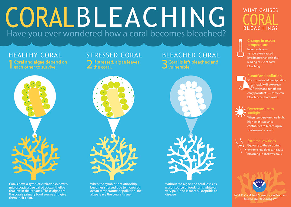
Q.47) Coral bleaching is the loss of algae causing the coral to turn white. What causes coral bleaching?
- Climate change which has drastically raised the temperature of ocean water has caused the corals to bleach
- Excess greenhouse gas especially CO2 absorbed by seawater causing ocean acidification dissolved the algae in the coral causing bleaching
Which of the above statements is/are correct?
a) 1 only
b) 2 only
c) Both 1 and 2
d) Neither 1 nor 2
a) 1 only
b) 2 only
c) Both 1 and 2
d) Neither 1 nor 2
Ans- [a]
Explanation– Water temperatures above than normal often results in coral bleaching. When water is too warm, corals expels the algae (zooxanthellae) living in their tissues causing them to turn completely white. When a coral bleaches, it is not dead. Corals can survive a bleaching event, they are just under huge stress.
This image very well explains it.

Ocean acidification slows down the growth of coral. Ocean absorbs one-third of the atmosphere’s excess carbon dioxide. This makes the ocean acidic which reacts with limestone skeleton of corals and dissolves them. In order for a coral reef to grow, it must produce limestone at a rate that is faster than the reef is being eroded. This slows down the growth.
Q.48) Four of the world’s biodiversity hotspots fall in India. Which of the following factors are considered for a place to become a biodiversity hotspot?a) Number of total species
b) Number of unique species
c) Number of species at risk
d) All of the above
b) Number of unique species
c) Number of species at risk
d) All of the above
Ans- [D]
Explanation:A biodiversity hotspot is a biogeographic region with significant levels of biodiversity that is under threat from humans. To qualify as a biodiversity hotspot, a region must meet two strict criteria: it must contain at least 0.5% or 1,500 species of vascular plants asendemics, and it has to have lost at least 70% of its primary vegetation.
Endemic species are species which are unique to a defined geographic location.
Q.4) The physical world map shows that there is a certain definite pattern to the location of the world’s deserts. Consider the following statements in this context-
- Almost all deserts lie within 15 and 30 degrees north and south of the equator
- Almost all deserts lie in the trade wind belt on the western parts of the continent
Which of the above statements is/are correct?
a) 1 only
b) 2 only
c) Both 1 and 2
d) Neither 1 nor 2
a) 1 only
b) 2 only
c) Both 1 and 2
d) Neither 1 nor 2
Ans-[C]
Explanation: Statement 1 is correct. Majority of the world deserts are found along the Tropic of Cancer, between 15 and 30 degrees north of the Equator, or along the Tropic of Capricorn, between 15 and 30 degrees south of the Equator.
Statement 2 is also correct. These desert lie in the trade wind belt on the western parts of the continents. Here trade winds are off-shore and they are influenced by cold currents which produce a ‘desiccating effect’. This causes very less rain.
Q.49) Secondary circulation in the atmosphere consists of
- Polar easterlies
- Temperate cyclones
- Mountain wind
- Monsoon
- Sea breeze
Select the correct answer using the codes given below:
a) 1 and 4 only
b) 2 and 4 only
c) 1, 2 and 4 only
d) 3 and 5 only
a) 1 and 4 only
b) 2 and 4 only
c) 1, 2 and 4 only
d) 3 and 5 only
Ans- [B]
Explanation:Atmospheric circulation is categorized as
- Primary circulation – General, worldwide patterns, planetary winds eg westerlies winds
- Secondary circulation- Regional circulation patterns (e.g. monsoons that are limited to South and South-east Asia)
- Tertiary circulation – Local winds for ex- Loo, Sea breeze, land breeze, Mountain winds and Valley breezes are known as Tertitary circulation.
Polar easterlies is an example of global pattern or primary circulation.
Cyclone, anticyclones, monsoon are example of regional circulation pattern.
Hence ans is 2 and 4 only
Q.50) Three major hills of the Purvanchal are-
- Naga hills
- Patkai hills
- Lushai hills
Arrange these hills in the right order from north to south using the codes given below:
a) 1, 3, 2
b) 2, 1, 3
c) 3, 1, 2
d) 2, 3, 1
a) 1, 3, 2
b) 2, 1, 3
c) 3, 1, 2
d) 2, 3, 1
Ans- [B]
Explanation- Mizo hills were formerly known as Lushai hills. See Atlas.
Q.51) Punjab and Haryana exploit almost 85% of groundwater for irrigation. The reason is –
- Low surface water availability
- Impact of green revolution
- Change in cropping pattern with an increased preference of rice
Select the correct answer using the codes given below:
a) 1 only
b) 2 only
c) 3 only
d) 1, 2 and 3
a) 1 only
b) 2 only
c) 3 only
d) 1, 2 and 3
Ans-[D]
Explanation- Statement 2 is obvious reason. Due to the green revolution and change in the cropping diversification in these states towards rice has unprecedentedly exploited groundwater resources.
Q.52) Biological Oxygen Demand (BOD) differs from Chemical Oxygen Demand (COD), on what grounds?
- BOD is the amount of dissolved oxygen demanded by aerobic biological organisms to break down organic material present in a given water sample at certain temperature.
- COD is a measurement of the oxygen required to oxidize only the soluble organic matter in water.
Which of the statements given above is/are correct?
a) 1 only
b) 2 only
c) Both 1 and 2
d) Neither 1 nor 2
a) 1 only
b) 2 only
c) Both 1 and 2
d) Neither 1 nor 2
Ans- [A]

Explanation– Biochemical Oxygen Demand or BOD is a measure of the amount of dissolved oxygen required for the aerobic bacteria to assimilate and oxidize the organic components present in water or waste water at a certain temperature. Higher the BOD value, higher the organic pollution in water.
Chemical Oxygen Demand or COD is a measure of the capacity of water to consume oxygen during the decomposition of organic matter and the oxidation of inorganic chemicals such as ammonia and nitrite. Statement 2 is thus wrong.
Q.53) Bio-fertilizers has been in news recently, which of the following nutrients can be supplied by Bio-fertilizers?
- (N) – Nitrogen
- (P) – Phosphorous
- (K) – Potassium
Which of the options given above is/are correct?
a) 1 only
b) 1 and 2 only
c) 1 and 3 only
d) 1, 2 and 3
a) 1 only
b) 1 and 2 only
c) 1 and 3 only
d) 1, 2 and 3
Ans-[D] Explanation– A Bio-fertilizer is a substance which contains living or latent microorganisms which, when applied to seeds, plant surfaces, or soil, colonizes the rhizosphere or the interior of the plant and promotes growth by increasing the supply or availability of primary nutrients to the host plant. They accelerate certain microbial processes in the soil which augment the extent of availability of nutrients in a form easily assimilated by plants.
These bio-fertilizer are valuable in not only providing nutrients such as N,P, and K but also mobilizes native soil phosphorous and render it available to crops.
Q.54) Extinct species can be considered as:
- Extinct species are the one which are no more present in wild areas.
- Extinct species are the one which are no more present in managed areas.
Which of the statement/s given above is/are correct?a) 1 only
b) 2 only
c) Both 1 and 2
d) None of the above
b) 2 only
c) Both 1 and 2
d) None of the above
Ans-[C] Explanation- Extinction of a particular animal or plant species occurs when there are no more individuals of that species alive anywhere in the world whether it is wild area or a managed area. The one which is present in the managed areas but absent in wild areas is known as extinct in the wild.
Q.55) Mercury Pollution may be caused due to which of the following?
- Coal based thermal power plants.
- Exhausts from supersonic jets.
- Automobiles exhaust
- Thermal waste incinerators
Select the correct answer using the codes given below.
a) 1, 2 and 3 only
b) 1, 3 and 4 only
c) 1 and 3 only
d) 1 and 4 only
a) 1, 2 and 3 only
b) 1, 3 and 4 only
c) 1 and 3 only
d) 1 and 4 only
Ans-[B] Explanation– Artificial sources include – Alkali and metal processing, incineration of coal(in power plants too), medical waste and waste incinerators, electrical/electronics devices, automobiles exhaust and mining of gold and mercury. Natural sources of mercury pollution are volcanoes, geologic deposits of mercury and volatilization from the ocean. Often some springs are naturally high in mercury concentration.
Q.56) Namdapha National Park is situated in which state of India?a) Nagalandb) Arunachal Pradeshc) Manipurd) Meghalaya
Ans- [B] Explanation– It is the largest protected area in the Eastern Himalaya biodiversity hotspot and is located in Arunachal Pradesh. It is also the third largest national park in India in terms of area.
Q.57) Northern hemisphere experiences its longest day and shortest night on summer solstice due to
- sun vertical over equator
- sun vertical over Tropic of Cancer
- inclined axis of the earth
Select the correct answer using the codes given below:
a) 1 only
b) 2 only
c) 2 and 3 only
d) 1 and 3 only
a) 1 only
b) 2 only
c) 2 and 3 only
d) 1 and 3 only
Ans- [B]

Explanation– As you can see in the diagram, Sun shines vertically over tropic of cancer during summer solstice. This is the time when there is summer season in N-Hemisphere. It shines vertically over tropic of capricorn in winter solstice and during this time there is winter season in N-hemisphere. When it shines vertically over equator it is known as equinoxes.
Q.58) Consider the following regions
- Darbhanga
- Koena
- Rann of Kutch
Which of the above places have a fault line that causes frequent and major earthquakes?
a) 1 and 2 only
b) 2 and 3 only
c) 1, 2 and 3
d) none of the above
a) 1 and 2 only
b) 2 and 3 only
c) 1, 2 and 3
d) none of the above
Ans-[C] Explanation– Rann of kutch has many fault lines as you can read in this the Hindu article. The earthquake in Koena region, Maharashtra are due to river fault. Darbhanga region falls in zone 5 seismicity.
Q.59) Landforms created by river during upper course, middle course and Lower course has been shown in pairs.
Landforms River Course
- U-shape valley : Lower course
- Delta : upper course
- ox-bow lakes : lower course
which of the following pairs are correctly matched?
a) 1 and 3 only
b) 1 and 2 only
c) 3 only
d) 2 and 3 only
a) 1 and 3 only
b) 1 and 2 only
c) 3 only
d) 2 and 3 only
Ans- (c)
Explanation-Upper-course -steep-sided V-shaped valleys, interlocking spurs, rapids, waterfalls and gorges.
Middle-course -wider, shallower valleys, meanders, and oxbow lakes.
Lower-course – wide flat-bottomed valleys, floodplains, ox-bow lakes and deltas.
[ox-bow lakes are found in lower course of river as well, for reference, check 2nd page of chapter 3 of NCERT Class IX of Geography] Therefore, option (c) would be correct answer.
Q.60) Which among the following are examples of hot deserts located between 15 to 30 degrees North and South and on the western coasts of continents?
- Patagonian desert
- Takla Makan
- Atacama desert
- Great Australian desert
Select the correct answer using the codes given below.
a) 1 and 2 only
b) 1 and 3 only
c) 3 and 4 only
d) 1, 3 and 4 only
a) 1 and 2 only
b) 1 and 3 only
c) 3 and 4 only
d) 1, 3 and 4 only
Ans – [C]
Explanation- It is simple atlas based question.
Q.61) Peninsular plateau incorporates which of the following portion in India?
- Peninsula of Kutch
- Aravali ranges
- Plateau of Meghalaya
Select the correct answer using the codes given below.
a) 1 and 2 only
b) 1 and 3 only
c) 2 and 3 only
d) 1, 2 and 3
a) 1 and 2 only
b) 1 and 3 only
c) 2 and 3 only
d) 1, 2 and 3
Ans- [C]
Explanation- Karbi-Meghalaya plateau is an extension of the main Indian peninsular plateau. Peninsula of kutch was once an island and surrounded by seas and lagoons until it was filled up. The filling was perhaps through sediments brought down by Indus river. In this way it became part of mainland.
Q.62) Tides occur in the oceans and seas due to which among the following?
- Gravitational force of the Sun
- Gravitational force of the Moon
- Centrifugal force of the Earth
Select the correct answer using the code given below.
a) 1 only
b) 2 and 3 only
c) 1 and 3 only
d) 1, 2 and 3
a) 1 only
b) 2 and 3 only
c) 1 and 3 only
d) 1, 2 and 3
Ans-[D] Explanation– Tides are the rise and fall of sea levels caused by the combined effects of the gravitational forces exerted by the Moon and the Sun and the rotation of the Earth.
An object traveling in a circle behaves as if it is experiencing an outward force. This force is known as the centrifugal force. Water on sea experience this force due to rotation of the earth.
The moon and the sun’s gravity tries to pull at anything on the Earth to bring it closer. But, the Earth is able to hold onto everything except the water. Since the water is always moving, the Earth cannot hold onto it, and the moon is able to pull at it. Each day, there are two high tides and two low tides. The ocean is constantly moving from high tide to low tide, and then back to high tide. There is about 12 hours and 25 minutes between the two high tides.
This gif image beautifully explains tides formation.
To a much smaller extent, tides also occur in large lakes, the atmosphere, and within the solid crust of the earth, acted upon by these same gravitational forces of the moon and sun.
Q.63) With reference to ‘Eco-Sensitive Zones’, which of the following statements is/are correct?
- Eco-Sensitive Zones are the areas that are declared under the Wildlife (Protection) Act, 1972 .
- The purpose of the declaration of Eco-Sensitive Zones is to prohibit all kinds of human activities, in those zones except agriculture.
Select the correct answer using the code given below.
a) 1 only
b) 2 only
c) Both 1 and 2
d) Neither 1 nor 2
a) 1 only
b) 2 only
c) Both 1 and 2
d) Neither 1 nor 2
Ans-[D] Explanation- As per
http://www.moef.nic.in/downloads/public-information/Guidelines%20for%20Eco-Sensitive%20Zone.pdf
http://www.moef.nic.in/downloads/public-information/Guidelines%20for%20Eco-Sensitive%20Zone.pdf
Eco sensitive zones are declared under Environment (Protection) Act, 1986. Eco sensitive zones are area in and around National Park and sanctuaries which are considered as eco fragile zones. There are some activities allowed in these areas like cottage industries, erection of telecom and electricity wires, tourism, hot-air balloons, tourism and so on.
Q.64) Which one of the following pairs is correctly matched?
Geographical Feature Regiona) Abyssinian Plateau : Arabiab) Atlas Mountains : North-Western Africac) Guiana Highlands : South-Western Africad) Okavango Basin : Patagonia
Ans-[B] Explanation- Atlas mountain is in NW Africa
Abyssinian plateau is in Ethiopia (in Africa)
Guiana Highland is in South America
Okavango basin/swamp is in Southern part of in Africa.
Q.65) In India, the problem of soil erosion is associated with which of the following?
- Terrace cultivation
- Deforestation
- Tropical climate
Select the correct answer using the code given below.
a) 1 and 2 only
b) 2 only
c) 1 and 3 only
d) 1, 2 and 3
a) 1 and 2 only
b) 2 only
c) 1 and 3 only
d) 1, 2 and 3
Ans-[B] Explanation– Terrace cultivation is the method of growing crops on side of hills mountains by planting on graduated terraces built into the slope. The method has been employed effectively to maximize arable land area in variable terrains and to reduce soil erosion and water loss. Thus, with this definition, option a,c and d are eliminated.
Q.66) Which one of the following National Parks has a climate that varies from tropical to subtropical, temperate and arctic?a) Khangchendzonga National Park
b) Nandadevi National Park
c) Neora Valley National Park
d) Namdapha National Park
b) Nandadevi National Park
c) Neora Valley National Park
d) Namdapha National Park
And-[D] Explanation– Namdapha National Park is the largest protected area in the Eastern Himalaya biodiversity hotspot and is located in Arunachal Pradesh in Northeast India. The habitat changes with increasing altitude from tropical moist forests to Montane forests, temperate forests and at the higher elevations, to Alpine meadows and perennial snow. The park has extensive bamboo forests and secondary forests in addition to the primary forests.
Q.67) The seasonal reversal of winds is the typical characteristic ofa) Equatorial climate
b) Mediterranean climate
c) Monsoon climate
d) All of the above climates
b) Mediterranean climate
c) Monsoon climate
d) All of the above climates
Ans-[C] Explanation– Equatorial climate has no seasonal reversal of wind. Thus, optionA and D are eliminated and Monsoon denotes the climate associated with seasonal reversal in the direction of winds.
Q.68) Acid rain is caused by the pollution of environment bya) carbon dioxide and nitrogen
b) carbon monoxide and carbon dioxide
c) ozone and carbon dioxide
d) nitrous oxide and sulphur dioxide
b) carbon monoxide and carbon dioxide
c) ozone and carbon dioxide
d) nitrous oxide and sulphur dioxide
Ans-[D]
Explanation This is very simple question. Acid rain is caused by emissions of sulfur dioxide and nitrogen oxide, which react with the water molecules in the atmosphere to produce acids.
Q.69) Variations in the length of daytime and nighttime from season to season are due toa) the earth’s rotation on its axis
b) the earth’s revolution round the sun in an elliptical manner
c) latitudinal position of the place
d) revolution of the earth on a tilted axis
b) the earth’s revolution round the sun in an elliptical manner
c) latitudinal position of the place
d) revolution of the earth on a tilted axis
Ans-[D]
Explanation- This is due to revolution of earth around the sun on it’s tilted axis which causes this variations. Solstices and equinoxes are characteristic phenomenon due to this thing.
Q.70)Consider the following pairs :
Wetlands Confluence of rivers
- Harike Wetlands : Confluence of Beas and Satluj/Sutlej
- Keoladeo Ghana National Park : Confluence of Banas and Chambal
- Kolleru Lake : Confluence of Musi and Krishna
Which of the above pairs is/are correctly matched?
a) 1 only
b) 2 and 3 only
c) 1 and 3 only
d) 1, 2 and 3
Ans[A] Explanation- Harike wetland is Situated on the confluence of the river Beas and Sutlez at the Ferozepur and Amritsar border.
Kolleru Lake, also called Colair Lake,lake in northeastern Andhra Prades hstate, southern India. It lies between the Godavari and Krishna river deltas near the city of Eluru.
Keoladeo national park is formed by inundation of Gambira and Banganga rivers
Q.71) Consider the following currents in the world.1. Humboldt current
2. Alaskan current
3. Brazil current
4. Kuroshio current
5. Falkland current
6. Aghulhas current
7. East Australia current
2. Alaskan current
3. Brazil current
4. Kuroshio current
5. Falkland current
6. Aghulhas current
7. East Australia current
Which of the currents given above is/are cold current?
a) 1, 3, 4, 5 and 7 only
b)1 and 5 onlyc) 2, 6 and 7 only
d)2, 4 and 6 only
a) 1, 3, 4, 5 and 7 only
b)1 and 5 onlyc) 2, 6 and 7 only
d)2, 4 and 6 only
Ans-[B] Explanation– The Humboldt Current is a cold, low-salinity ocean current that flows north along the west coast of South America from the southern tip of Chile to northern Peru. Also called the Peru Current, it is an eastern boundary current flowing in the direction of the equator, and can extend 1,000 kilometers offshore.
The Falkland Current (also called Malvinas Current or Falklands Current) is a cold water current that flows northward along the Atlantic coast of Patagonia as far north as the mouth of the Río de la Plata. This current results from the movement of water from the West Wind Drift as it rounds Cape Horn. It takes its name from the Falkland Islands.
The Alaska Current is a southwestern warm-water current along the coast of British Columbia.
The Brazil Current is a warm water current that flows south along the Brazilian south coast to the mouth of the Río de la Plata. This current is caused by diversion of a portion of the Atlantic South Equatorial Current from where that current meets the South American continent.
The Kuroshio is a north-flowing ocean current on the west side of the North Pacific Ocean. It is similar to the Gulf Stream in the North Atlantic and is part of the North Pacific ocean gyre.
The Agulhas Current is the warm water current of the southwest Indian Ocean.
The East Australian Current is the southward western boundary warm current that is formed from the South Equatorial Current reaching the eastern coast of Australia.
Q.72) Consider the following tributaries.1. Alaknanda
2. Bhagirathi
3. Dhansiri
4. Gandhak
2. Bhagirathi
3. Dhansiri
4. Gandhak
Which of the above rivers are tributaries of River Ganges?
a) 1 and 2 only
b) 2, 3 and 4 only
c) 1, 2 and 4 onlyd) 1, 2, 3 and 4
a) 1 and 2 only
b) 2, 3 and 4 only
c) 1, 2 and 4 onlyd) 1, 2, 3 and 4
Ans-[C] Explanation – This is basic NCERT question. Ganga river is formed by the Gangotri Glacier, a vast expanse of ice, five miles by fifteen, at the foothills of the Himalayas in North Uttar Pradesh, is the source of Bhagirathi, which joins with Alaknanda to form Ganga at Devprayag. The Gandhak, which comes from near Katmandu, is another big Himalayan tributary.
Dhansiri is tributary of Brahamputra.
Q.73) Consider the following statements.1. Lagoons are comparatively less in numbers on eastern coast.
2. Western coastal plain has indented coast which support many ports.
2. Western coastal plain has indented coast which support many ports.
Select the correct statement using the codes given below.
a) 1 only
b) 2 only
c) Both 1 and 2d) Neither 1 nor 2
a) 1 only
b) 2 only
c) Both 1 and 2d) Neither 1 nor 2
Ans-[C] Explanation–
Lagoons are comparatively less in eastern coastal plain of India. It has more or less a straight coast where good ports are lacking. Mostly it is of emergent type, characterized by offshore bars, fine sea beaches, sand ridges and lagoons.
Lagoons are comparatively less in eastern coastal plain of India. It has more or less a straight coast where good ports are lacking. Mostly it is of emergent type, characterized by offshore bars, fine sea beaches, sand ridges and lagoons.
The western coastal plain is quite indented and is marked by caves (small sheltered recess in the coast) and creeks and suitable for ports.
Q.74) Which of the following reasons are associated with decrease in salinity of sea-water?1.High temperature
2.High Humidity
3. Presence of winds
4. Presence of river water
2.High Humidity
3. Presence of winds
4. Presence of river water
Select the correct answer using the codes given below.
a) 4 only
b) 2 and 4 only
c) 2, 3 and 4 only
d) 1, 2, 3 and 4
a) 4 only
b) 2 and 4 only
c) 2, 3 and 4 only
d) 1, 2, 3 and 4
Ans-[D] Explanation- High temperature and wind increases rate of evaporation which increases the salinity. Humidity has no impact on salinity. Presence of river water dilutes the saline concentration and thus, decreases salinity.
Q.75) Consider the following phenomena.1. Equatorial low pressure belts extends well into the southern hemisphere
2. Low pressure is developed over Australia
3. Subtropical high pressure system is formed only over the ocean
2. Low pressure is developed over Australia
3. Subtropical high pressure system is formed only over the ocean
In which of the following months, above phenomena occurs?
a) Januaryb) July
c) March
d) September
c) March
d) September
Ans-[A] Explanation- This happens in the month of January. During this time there is summer season in the southern hemisphere and low pressure belts extends well into it. Low pressure develops over Australia. As there is less land in southern hemisphere, subtropical high pressure majorily develops over oceans.
Q.76) Consider the following statements:1. Madras crocodile Bank trust(MCBT)is the first crocodile conservation breeding centre of Asia.
2. MCBT started first sea turtle survey and their conservation program.
2. MCBT started first sea turtle survey and their conservation program.
Select the correct statement using the codes given below.
a) 1 Only
b) 2 Only
c) Both 1 and 2d) Neither 1 nor 2
a) 1 Only
b) 2 Only
c) Both 1 and 2d) Neither 1 nor 2
Ans-[C] Explanation– Both the statements are true. MCBT is the first ever crocodile conservation breeding centre of Asia. It is also one of the largest reptile zoo in the world. MCBT started first sea turtle survey and their conservation program.
Q.77) Consider the following statements:1. SACON was established by India’s famous ornithologist. Salim Ali.
2. It is part of the BNHS.
2. It is part of the BNHS.
Select the correct statement using the codes given below.
a) 1 Only
b) 2 Only
c) Both 1 and 2
d) Neither 1 nor 2
a) 1 Only
b) 2 Only
c) Both 1 and 2
d) Neither 1 nor 2
Ans-[D] Explanation – Salim Ali Centre for Ornithology and Natural History (SACON) is a national centre for information, education and research in ornithology and natural history in India. It was inspired by, established and named in honour of Salim Ali after his death, the leading pioneer of ornithology in India. It is an autonomous organisation established in 1990 and registered under the Indian Societies Registration and thus not a part of BNHS.
Q.78) Toxic substance released in Bhopal Gas tragedy was:a) Arsine
b) Cyanogen chloride
c) Boron tri-bromide
d) Methyl Isocynate
b) Cyanogen chloride
c) Boron tri-bromide
d) Methyl Isocynate
Ans-[D] Explanation– MIC or Methyl Isocynate was the gas releases in Bhopal Gas tragedy.
Q.79) Consider the following statements.1. Lithosphere is a part of Biosphere.
2. Deforestation is the major cause of drought.
2. Deforestation is the major cause of drought.
Select the correct statement using the codes given below.
a) 1 Only
b) 2 Only
c) Both 1 and 2d) Neither 1 nor 2
a) 1 Only
b) 2 Only
c) Both 1 and 2d) Neither 1 nor 2
Ans-[C] Explanation- Lithosphere, Hydrosphere and Atmosphere are parts of Biosphere. Deforestation is one of the cause of drought.
Q.80) Which of the following is the result of the Bio-accumulation of DDT in birds?1. Premature breaking of eggs.
2. Thinning of the shell of eggs.
2. Thinning of the shell of eggs.
Select the correct answer using the codes given below.
a) 1 Only
b) 2 Only
c) Both 1 and 2d) Neither 1 and 2
a) 1 Only
b) 2 Only
c) Both 1 and 2d) Neither 1 and 2
Ans-[C] Explanation- Bioaccumulation of DDT in birds causes thinning of the shell of eggs which results in the premature breaking of eggs.
Q.81) Select the incorrect statement about trade winds:a) Trade winds are also called as easterlies.b) They are the part of Hadley cell.c) In N-hemisphere they are deflected anticlockwise and clockwise in S-hemisphere.d) None of these
Ans – [C] Explanation – Due to Coriolis force trade winds get deflected in clockwise direction in N-hemisphere and in anticlockwise direction in S-Hemisphere.
Q.82) Consider the following statements about Harmattan winds.1. Interaction of Harmattan winds with monsoon produces tornadoes2. It is dry and dusty west African trade winds.
Select the correct statement using the codes given below.
a) 1 onlyb) 2 onlyc) Both 1 and 2d) Neither 1 nor 2
a) 1 onlyb) 2 onlyc) Both 1 and 2d) Neither 1 nor 2
Ans – [C] Explanation – Harmattan, hot and dry wind that blows from the northeast or east in the western Sahara, is strongest in late fall and winter (late November to mid-March). It usually carries large amounts of dust, which it transports hundreds of kilometers out over the Atlantic Ocean; the dust often interferes with aircraft operations and settles on the decks of ships. The interaction between the Harmattan and the monsoon sometimes produces West African tornadoes.
Q.83) Consider the following statements about tropical cyclone.1. They are formed over low pressure area generally2. Environment inside the tropical cyclone is warmer than its surroundings.
Select the correct statement using the codes given below.
a) 1 onlyb) 2 onlyc) Both 1 and 2d) Neither 1 nor 2
a) 1 onlyb) 2 onlyc) Both 1 and 2d) Neither 1 nor 2
Ans – [C] Explanation – Statement 1 is right. Tropical cyclones are driven by the release of large amount of latent heat of condensation which occurs when moist air is carried upwards and its vapor condenses. Heat is distributed vertically around the centre of the storm. Environment inside the tropical cyclone is warmer than outside.
Q.84) Consider the following statements about Mangroves.1. It prevents soil erosion.2. It acts as breeding site for many sea organisms.3. It is one of the cause of marine pollution.
Select the correct answer using the codes given below.
a) 1 and 2 onlyb) 1 and 3 onlyc) 1 and 3 onlyd) 1, 2 and 3
a) 1 and 2 onlyb) 1 and 3 onlyc) 1 and 3 onlyd) 1, 2 and 3
Ans – [A] Explanation – Mangroves are shrubs or small trees that grow in coastal saline or brackish water. The term is also used for tropical coastal vegetation consisting of such species. Mangroves occur worldwide in the tropics and subtropics, Mangroves are salt tolerant trees, also called halophytes, and are adapted to life in harsh coastal conditions. They contain a complex salt filtration system and complex root system to cope with salt water immersion and wave action. They are adapted to the low oxygen (anoxic) conditions of waterlogged mud. Mangrove forests are not reason of marine pollution. Rest all above functions are performed by them.
Q.85) Consider the following statements regarding aerosols.1. Aerosols use has been suggested to reduce the incoming sunlight2. They can change cloud properties.
Select the correct statement using the codes given below.
a) 1 only
b) 2 only
c) Both 1 and 2
d) None of the above
a) 1 only
b) 2 only
c) Both 1 and 2
d) None of the above
Ans-[C] Explanation – An aerosol is a colloid of fine solid particles or liquid droplets, in air or another gas. Aerosols can be natural or artificial. Examples of natural aerosols are fog, forest exudates and geyser steam. Examples of artificial aerosols are haze, dust, particulate air pollutants and smoke. Statement 1 is correct. This technique is known as stratospheric aerosol injection. It involves spraying fine stratosphere fine, light colored particles designed to reflect part of the solar radiation before it reaches and warms the earth. Aerosol can change cloud properties. It was published in IPCC report. You can read about it here
Q.86) Which of the following is/are major reasons for Uttrakahnd Jungle Fire apart from role of Mafia?1. Migration of people outside state2. Presence of highly heat resistant chir pine tree3. Scanty rains
Select the correct answer using the codes given below.
a) 1 and 3 onlyb) 1 onlyc) 3 Onlyd) 1,2 and 3
a) 1 and 3 onlyb) 1 onlyc) 3 Onlyd) 1,2 and 3
Ans – [D] Explanation – All three are said to be major reasons of Uttrakhand jungle fire which took such a big scale. Chir pine tree is highly heat resistant due to presence of a very thick cork but it produces chir pine needles which have resins in them. These needles are highly inflammable. Though villagers were using them as livestock bedding, biomass and compost but recent years have seen huge migration of people outside state. Due to this, these chir pine needles have remain unutilized and lied scattered on ground.
Scanty rains have also dried the vegetation and thus it helped in increase of area of fire.
Q.87) Which of the following are objectives of National Forest Policy?1. Maintenance of environmental stability through preservation2. Checking soil erosion and denudation in the catchment areas of rivers, lakes, reservoirs3. Diversion of good and productive agricultural lands to forestry
Select the correct answer using the codes given below.
a)1 Onlyb)1 and 3 Onlyc)1 and 2 onlyd)1, 2 and 3
a)1 Onlyb)1 and 3 Onlyc)1 and 2 onlyd)1, 2 and 3
Ans-[C] Explanation – The basic objectives that should govern the National Forest Policy – are the following: ·1. Maintenance of environmental stability through preservation and, where necessary, restoration of the ecological balance that has been adversely disturbed by serious depletion of the forests of the country. ·2. Conserving the natural heritage of the country by preserving the remaining natural forests with the vast variety of flora and fauna, which represent the remarkable biological diversity and genetic resources of the country. ·3. Checking soil erosion and denudation in the catchment areas of rivers, lakes, reservoirs in the “interest of soil and water conservation, for mitigating floods and droughts and for the retardation of siltation of reservoirs. ·4. Checking the extension of sand-dunes in the desert areas of Rajasthan and along the coastal tracts. ·5. Increasing substantially the forest/tree cover in the country through massive afforestation and social forestry programmes, especially on all denuded, degraded and unproductive lands. ·6. Meeting the requirements of fuel-wood, fodder, minor forest produce and small timber of the rural and tribal populations. ·7. Increasing the productivity of forests to meet essential national needs. Encouraging efficient utilization of forest produce and maximizing substitution of wood. ·8. Creating a massive people’s movement with the involvement of women, for achieving these objectives and to minimize pressure on existing forests.
Q.88) Which of the following is not a major functions of Ministry of Environment and forests?1. Survey of flora and fauna and wildlife2. Ensuring welfare of animals3. Prevention of pollution4. Afforestation
Select the correct answer using the codes given below.
a) 1 onlyb) 1 and 2 onlyc) 1 2 and 3 onlyd) 1,2,3 and 4
a) 1 onlyb) 1 and 2 onlyc) 1 2 and 3 onlyd) 1,2,3 and 4
Ans – [A] Explanation – MoEF is nodal agency in the admin structure of the Union govt for the planning promotion coordination and overseeing the implementation of India’s environmental and forestry policies and programmes.
Broad objectives are1. Conservation of forest, flora , fauna and wildlife2. Prevention and control of pollution3. Afforestation4. Ensuring welfare of animals5. Protection of environment
Q.89) Consider the following statements regarding Algal Bloom.
1. All algal blooms are green in color.2. Algal bloom always occur in fresh-water.
1. All algal blooms are green in color.2. Algal bloom always occur in fresh-water.
Select the correct answer using the codes given below.
a) 1 onlyb) 2 onlyc) Both 1 and 2d) None of the above.
a) 1 onlyb) 2 onlyc) Both 1 and 2d) None of the above.
Ans – [D] Explanation – Statement 1 is wrong as all algal blooms are not green, they can be red and brown too. Algal bloom can occur in sea water and it is wrong to say that they always occur in fresh water.
Q.90) Arrange the following in decreasing order of Global warming potential.1. Perfluoromethane2. Sulphur Hexafluoride3. HCFC 224. Nitrous Oxide
Select the correct answer using the codes given below.
a) 1>3>2>4b) 2>3>1>4c) 4>3>1>2d) 2>1>3>4
a) 1>3>2>4b) 2>3>1>4c) 4>3>1>2d) 2>1>3>4
Ans – [D] Explanation – Sulphur Hexafluoride has highest global warming potential (GWP) which is equal to 23,900. Perfluoromethane has GWP of 6500. HCFC 22 has GWP of 1300-1400 and Nitrous oxide has 310.


Q.91) Arrange the following mountains from North to south direction.1. Maikala Range2. Balaghat Range3. Kaimur Range4. Ajanta Range
Select the correct answer using the codes given below.
a) 3, 1, 4, 2b) 1, 2, 3, 4c) 3, 1, 2, 4d) 1, 2, 4, 3
a) 3, 1, 4, 2b) 1, 2, 3, 4c) 3, 1, 2, 4d) 1, 2, 4, 3
Ans-[A]

Q.92) Consider the following statements about Savanna grass ecosystem.
1. It is a temperate grassland.2. Trees are so close to each other that sunlight can not reach to the ground.3. It is also known as a paradise of hunters.
Which of the following statement(s) is/are correct?a) 1 and 3 onlyb) 2 and 3 onlyc) 1 onlyd) 3 only
Ans – [D] Explanation- Savanna are tropical grasslands that are located near the equator, between the Tropic of Cancer and the Tropic of Capricorn. They cover much of Africa as well as large areas of Australia, South America, and India. They may have some drought-resistant, fire-resistant or they may have an open shrub layer. Savanna is characterized by the trees being sufficiently widely spaced so that the canopy does not close. The open canopy allows sufficient light to reach the ground to support an unbroken herbaceous layer consisting primarily of grasses. Savanna is also known as a paradise of the hunters.
Q.93) Which of the following does not affect salinity of the ocean?a) Latitudeb) Temperaturec) Ocean currentsd) Tides
Ans-[D] Explanation- Tides have no effect on the salinity of the ocean. Salinity generally decreases from equator to poles. Temperature and ocean currents affects salinity.
Q.94) Consider the following statements.1. Antarctica has no Biomes.2. Biomes are characterized on the basis of climatic factors only.
Select the incorrect statement using the codes given below.
a) 1 onlyb) 2 onlyc) Both 1 and 2d) None of the above
a) 1 onlyb) 2 onlyc) Both 1 and 2d) None of the above
Ans – [C] Explanation – Biomes are regions of planets that are characterized and distinguished on the basis of climate, flora and fauna. Antarctica is the coldest, windiest, and driest biome on Earth. There is not a lot of life on the Antarctic land.
Q.95) Consider the following statements about Eutrophication.1. It decreases the Biochemical Oxygen demand of water.2. It increases the biomass of phytoplanktons.
Which of the above statements is/are correct?
a) 1 onlyb) 2 onlyc) Both 1 and 2d) None of the above
a) 1 onlyb) 2 onlyc) Both 1 and 2d) None of the above
Ans – [B] Explanation – Eutrophication occurs when large quantities of nutrients such as nitrates and phosphates enter an aquatic environment. Sources of these nutrients include animal wastes, agricultural runoff, and sewage. The ecosystem quickly experiences an increase in photosynthetic and blue-green algae, as these organisms thrive in the presence of the added nutrients. An algae bloom occurs as the algae accumulates into dense, visible patches near the surface of the water, prohibiting light from penetrating deeper areas of lake or stream. This can be a problem in marine habitats:
- This causes phytoplankton to grow and reproduce more rapidly, resulting in algal blooms. Hence statement 2 is correct. Biomass of phytoplanktons gets increased.
- This bloom of algae disrupts normal ecosystem functioning and causes many problems.
- The algae may use up all the oxygen in the water, leaving none for other marine life. This results in the death of many aquatic organisms such as fish, which need the oxygen in the water to live.
- The bloom of algae may also block sunlight from photosynthetic marine plants under the water surface.
- Some algae even produce toxins that are harmful to higher forms of life. This can cause problems along the food chain and affect any animal that feeds on them.
Some fish are unable to survive due to this, but for them an even more serious problem arises when the algae begin to die. At this point, oxygen-demanding bacteria take over the ecosystem, decomposing the algae and using up dissolved oxygen in the process. These bacteria increase the biological oxygen demand (BOD) of the ecosystem. BOD is the amount of oxygen required for the decomposition of organic compounds by microorganisms in a given amount of water.
Q.96) Consider the following statements about Oil Zapping technique.1. Hazardous hydrocarbons waste are converted into Carbon dioxide and water.2. This technique was developed by Centre for Science and Environment.
Which of the above statement(s) is/are correct?a) 1 onlyb) 2 onlyc) Both 1 and 2d) Neither 1 nor 2
Ans – [A] Explanation – Oil-zapper is essentially a combination of five different bacterial strains that are immobilized and mixed with a carrier material (powdered corncob). It is developed by TERI after seven years of research work and partly supported by the DBT (Department of Biotechnology), Ministry of Science and Technology, Government of India. Oil-zapper feeds on hydrocarbon compounds present in crude oil and oily sludge (a hazardous hydrocarbon waste generated by oil refineries) and converts them into harmless CO2 and water. The Oilzapper is neatly packed into sterile polythene bags and sealed aseptically for safe transport. The shelf life of the product is three months at ambient temperature.
Q.97) Consider the following statements about Biodiversity.1. High beta-diversity implies high similarity between species composition of different ecosystem.2. Alpha diversity represent diversity of the species within the ecosystem.3. Gamma diversity represents geographic scale species diversity.
Which of the above statement(s) is/are are incorrect?a) 1 onlyb) 2 onlyc) 3 onlyd) 2 and 3 only
Ans-[A] Explanation– Statement 2 and 3 are correct. And only statement 1 is incorrect. So, answer would be (a).Biological diversity – or biodiversity – is the term given to the variety of life on Earth and the natural patterns it forms. Ecologist classify biodiversity as alpha beta and gamma diversity.
Alpha-diversity refers to a group of organisms interacting and competing for the same resources or sharing the same environment. Thus it represents diversity of species within the ecosystem.
Beta-diversity compares the the diversity between the ecosystem. High beta-diversity implies low similarity between species composition of different habitats. It is usually expressed in terms of similarity index between communities. Following diagram illustrates it better.

Q.98) Which of the following countries borders Baltic Sea?1. Sweden2. Denmark3. Belarus4. Finland5. Lithuania6.Spain7.Russia
Select the correct answer using the codes given below.
a) 1, 2, 3, 6 and 7 onlyb) 1, 3, 4, 5 and 7 onlyc) 1, 2, 4, 5 and 7 onlyd) 1, 2, 3, 5, 6 and 7 only
a) 1, 2, 3, 6 and 7 onlyb) 1, 3, 4, 5 and 7 onlyc) 1, 2, 4, 5 and 7 onlyd) 1, 2, 3, 5, 6 and 7 only
Ans-[C] Explanation– See the map

Q.99) Consider the following statements related with the Godavari river.1. Indravati, Sabri and Bhima rivers are important tributaries of the Godavari river.2. It originates in Dandakaranya Plateau.3. It is navigable throughout its basin.
Which of the above statement(s) is/are correct?a) 1 and 3 onlyb) 1 and 2 onlyc) 1,2 and 3d) None of them
Ans-[D] Explanation- Godavari is the largest river of the Peninsular India. It is also known as Dakshin Ganga. Purna, Maner, Penganga, Pranhita, Indravati, Tal, Sabri and Manjira are its important tributaries. Bhima is the tributary of river Krishna. Hence statement 1 is wrong.
Godavari originates in the Trimbak Plateau at the spring near Nasik in Maharashtra. Mahanadi originates in the Dandakaranya Plateau near Raipur. Hence statement 2 is wrong.
Godavari is only navigable in the deltaic stretch of its course. Hence statement 3 is also wrong. Thus Option D is right ans.
Q.100) With respect to LIDAR, Consider the following statements.1. It is a remote sensing method.2. It uses light in the form of a pulsed laser.3. It can not be used to determine depth profiling of water.
Which of the above statements is/are correct?a) 2 and 3 onlyb) 1 onlyc) 1 and 2 onlyd) 1, 2 and 3
Ans – [C]
Explanation – LIDAR, which stands for Light Detection and Ranging, is a remote sensing method that uses light in the form of a pulsed laser to measure ranges (variable distances) to the Earth. These light pulses—combined with other data recorded by the airborne system— generate precise, three-dimensional information about the shape of the Earth and its surface characteristics.
A LIDAR instrument principally consists of a laser, a scanner, and a specialized GPS receiver. Airplanes and helicopters are the most commonly used platforms for acquiring LIDAR data over broad areas. Two types of LIDAR are topographic and bathymetric. Topographic LIDAR typically uses a near-infrared laser to map the land, while bathymetric lidar uses water-penetrating green light to also measure seafloor and riverbed elevations. Thus, it can be used to do depth profiling of the water.
Q.101) Consider the following statements.1. Subpolar low pressure belt is more develop in the southern Hemisphere2. The Roaring Forties are strong westerly winds found in the Southern Hemisphere
Select the correct statement using the codes given below.a) 1 onlyb) 2 onlyc) Both 1 and 2d) None of the above
Select the correct statement using the codes given below.a) 1 onlyb) 2 onlyc) Both 1 and 2d) None of the above
Ans – [C]
Q.102) Small dunes like formation that comprises smaller size deposit near glacier terminus is known asa) Eskerb) Kamesc) Drumlind) Outwash plain
Ans – [B]
Explanation– Kame are mound like hill of poorly sorted drift, mostly sand and gravel, deposited at or near the terminus of a glacier. A Kame may be produced either as a delta of a meltwater stream or as an accumulation of debris let down onto the ground surface by the melting glacier. A group of closely associated kames is called a kame field, or kame complex, and may be interspersed with kettles or kettle lakes. A kame terrace is produced when a meltwater stream deposits its sediments between the ice mass and the valley wall.
Q.103) Coco channel seperatesa) Little Andaman and south Andamanb) Andaman group of Islands from Myanmarc) Andaman from Nicobar islandsd)None of the above
Ans-[B]
Explanation– Coco channel’ is the name of passage between Little Coco island of Burma and Landfall island, a small islet off the coast of North Andaman Island of India; in the Bay of Bengal. It separates Andaman group of Islands from Myanmar.
Q.104) Which of the following are associated with the fluvio glacial deposits.1. Moraines2. Drumlins3. Esker
Select the correct answer using the codes given below.
a) 3 onlyb) 1 and 2 onlyc) 2 and 3 onlyd) 1, 2 and 3
a) 3 onlyb) 1 and 2 onlyc) 2 and 3 onlyd) 1, 2 and 3
Ans-[A]
Explanation Fluvio-glacial deposit mean sediments deposited by the glacier meltwater. Fluvio-glacial landforms differ from glacial landforms such as Moraines and drumlins. Such fluvio-glacial landforms include outwash plains, varves, braided streams, eskers, kames (and kame terraces), kettles (or kettle holes) and proglacial lakes.
Q.105) With respect to Tobacco, Consider the following statements.1. Well drained sandy soils are good for tobacco.2. Climate tolerance of tobacco plant is very poor.3. It can grow well without manures too.
Which of the above statements is/are incorrect?a) 1 onlyb) 2 and 3 onlyc) 1 and 2 onlyd) 1, 2 and 3
Ans – [B]
Explanation – Tobacco is very sensitive to the physical and chemical properties of the soil. The best soils are those which are open, well drained and properly aerated. The plant is highly susceptible to injury from flooding or inundation of the soil. The desirable soil pH is 5.0 to 6.0 . But, in many parts cultivation is successful where the pH is 8 or more.
In India, cigar, hookah, chewing and bidi tobaccos are grown on sandy loam to clay loams. The crop is raised either on irrigation as in Tamil Nadu and U.P. or as semi-irrigated crop as in Bihar, Bengal and Mysore or as a dry crop in Andhra.
Climate tolerance of the plant is very good except it can not bear frost. In India, tobacco is grown under a very wide range of conditions from the coast-line to an altitude of 3,000 feet. In the South, the crop is raised in winter from October to March when the temperatures are moderate, but in Punjab it is grown as an early summer crop. In the eastern and western parts of the country it is grown between September and January. Tobacco plant requires good application of manures.
Q.106) Which of the following regions usually experiences cold currents?1. Western coast of continents in the temperate region2. Western coast of continents in the tropical region3. Eastern coast of continents in the tropical region
Select the correct answer using the codes given below.
a) 1 onlyb) 2 onlyc) 1 and 2 onlyd)None of the above
a) 1 onlyb) 2 onlyc) 1 and 2 onlyd)None of the above
Ans-[B]
Explanation–A cold current brings cold water into warm water. Cold currents are usually found on the west coast of continents in the low and middle latitudes. And it is usually on the east coast on higher altitudes.
Q107). In the Indian sub-continent, rivers in Northern India have meandering path while rivers in South India do not have meanders. Which of the following explains this anomaly correctly?
1. Peninsular Region has a hard rock surface.
2. Peninsular River Basin are Non-alluvial
3. Peninsular Rivers have regular supply of water as compared to rivers in North India.
Select the correct answer using the codes given below.
a) 1 and 2 only
b) 1 and 3 only
c) 2 and 3 only
d)1, 2 and 3
Q108). Consider the following statements regarding the incoming insolation on Earth
1. The equator receives less insolation than the tropics.
2. Insolation is more over the oceans than over the continents at the same latitude
3. The Ocean reflect more of the incoming insolation than Deserts.
Which of the statements given above is/are correct?
a) 1 only
b) 2 and 3 only
c) 1 and 3 only
d) 1, 2 and 3 only
Q.109. Saline soils can be reclaimed by
1. Providing good drainage.
2. Applying lime or gypsum.
3. Cultivating salt resistant crops.
Select the correct answer using the codes given below.
a) 1 and 2 only
b) 1 and 3 only
c) 2 and 3 only
d) 1, 2 and 3
Q.110) Consider the following formations developed by the sea waves.
1. Stacks
2. Sea arches
3. Sea cliff
Which of the above formations are erosional features developed by sea waves?
a) 1 only
b) 2 and 3 only
c) 1 and 3 only
d) 1, 2 and 3
Q111). If the sea surface temperature were to rise, which of the following could be the possible outcomes?
1. Possibility of large storms would decrease
2. Salinity of oceans would increase
3. Coral Bleaching would take place
4. Habitat destruction of certain mammals would take place
5. Decrease in invasive species and overall loss of biodiversity
Select the correct statements using the codes given below.
a) 2, 3 and 4 only
b) 1, 3 and 4 only
c) 2, 3, 4 and 5 only
d) 1, 2, 3, 4 and 5
Q112). Consider the following statements:
1. Montreal Protocol mandates phasing out substances that deplete the ozone layer.
2. The Montreal Protocol is among the first universally ratified treaties in UN history
3. The ozone layer protects the earth from both UVA and UVB radiation.
Select the correct answer using the codes given below:
a) 1 only
b) 1 and 2 only
c) 2 and 3 only
d) 1, 2 and 3
Q113). Consider the following statements related to National Air Quality Index (AQI):
1. It is a comprehensive index to indicate the quality of air in a city and its impact on health.
2. Along with Green-house gases, AQI also monitors particulate matters.
3. Indian Meteorological Organisation is the agency in India that prepares it.
Select the correct statement using the codes given below.
a) 1 only
b) 1 and 3 only
c) 1 and 2 only
d) 1, 2 and 3 only
With reference to 'One Belt One Road' (OBOR) initiative, consider the following statements:
- It aims to connect Asia, Europe and Africa.
- Both maritime route and road route are an integral part of the initiative.
- China-Pakistan economic corridor is a part of OBOR.
Which of the statements given above is/are correct?
(a) 1 only
(b) 1 and 2 only
(c) 2 and 3 only
(d) 1, 2 and 3
- The Belt and Road Initiative refers to the Silk Road Economic Belt and 21st Century Maritime Silk Road, a significant development strategy launched by the Chinese government.
- The Belt and Road Initiative aims to connect Asia, Europe and Africa along five routes. The Silk Road Economic Belt focusses on: (1) linking China to Europe through Central Asia and Russia; (2) connecting China with the Middle East through Central Asia; and (3) bringing together China and Southeast Asia, South Asia and the Indian Ocean. The 21st Century Maritime Silk Road, meanwhile, focusses on using Chinese coastal ports to: (4) link China with Europe through the South China Sea and Indian Ocean; and (5) connect China with the South Pacific Ocean through the South China Sea. Hence, statement 1 is correct.
- It consists of two main components, the land-based 'Silk Road Economic Belt' (SREB) and oceangoing 'Maritime Silk Road' (MSR). Hence, statement 2 is correct.
- China-Pakistan Economic Corridor (CPEC), is also part of OBOR. Infrastructure projects under the CPEC will eventually link the Pakistani city of Gwadar in southwestern to China's northwestern autonomous region of Xinjiang via a vast network of highways and railways. Hence, statement 3 is correct.
7.Consider the following statements regarding 'solifluction':
- It is a slow mass movement of water-saturated soil.
- It is particularly widespread in permafrost regions.
- Absence of deep-rooted vegetation aids solifluction.
Which of the statements given above is/are correct?
(a) 1 and 2 only
(b) 1 and 3 only
(c) 2 and 3 only
(d) 1, 2 and 3
- Solifluction invloves slow downslope flowing soil mass or fine grained rock debris saturated with water. It is particularly widespread in permafrost regions.
- Permafrost refers to the layer of groundwater that fills in the pore spaces of soil and rock that is permanently frozen. Because permafrost is impermeable to water, in summers, soil overlying it may become saturated and slide downslope under the pull of gravity.
- Soil that has been opened and weakened by frost action is most susceptible. In addition, absence of deep-rooted vegetation to bind the soil aids solifluction. Therefore, all statements are correct.
8.'A region which was a part of erstwhile Gondwanaland, has a remarkable proportion of flightless birds with almost no native terrestrial mammals and a few reptiles and amphibians.' Which of the following countries is best described by the statement given above?
(a) Madagascar
(b) Australia
(c) New Zealand
(d) Greenland
- The New Zealand Region has a unique fauna dominated by birds, with remarkable proportion of flightless types. It has almost no terrestrial vetebrates (no mammals; only a few reptiles and amphibians).
98% of the total coal reserves in India belong to the Gondwana period.
Indian coal is mainly lignite with the carbon content varying between 40 to 50 per cent.
Non- coking coal comprises major share of Indian coal.
Which of the statements given above is/are correct?
(a) 1 only
(b) 1 and 3 only
(c) 2 and 3 only
(d) 1, 2 and 3
Coal found in India belongs to two geological periods: the Gondwana and the Tertiary. Of the 113 coalfields found in the country, 80 belong to the Lower Gondwana period. These account for over 98% of the total reserves and 99% of the production of coal in India. The Gondwana coal has carbon content between 55 and 60 per cent, high volatile matter and ash contents. It is mainly bituminous and anthracite. While total coal reserves are estimated at 111.83 billion tonnes, total lignite reserves are estimated at 38.93 billion tonnes only.
The coal is both coking and non-coking. However, non-coking coal comprises lion's share of Indian coal. The estimated reserve of coking coal is about 29.70 billion tonnes while non-coking coal reserves being 166.32 billion tonnes
10.crops and seasons
- In India there are three major cropping seasons: Rabi, Kharif and Zaid. The kharif cropping season is from July -October during the south-west monsoon and the Rabi cropping season is from October-March (winter).
- The kharif crops include rice, maize, sorghum, pearl millet/bajra, finger millet/ragi (cereals), arhar (pulses), soyabean, groundnut (oilseeds), cotton etc. The rabi crops include wheat, barley, oats (cereals), chickpea/gram (pulses), linseed, mustard (oilseeds) etc.
- The Zaid season is in the short duration between Rabi and Kharif crop season, mainly from March to June. They require warm dry weather for major growth period and longer day length for flowering. The main produce are seasonal fruits and vegetables. Water melon, cucumber , muskmelon and sunflower are some examples.
11.With reference to Hotspots, consider the following statements:
- Hotspots are volcanic regions found along plate boundaries.
- Formation of Hawaiian island is a result of hotspot activity.
- Atlantic Ocean is devoid of any hotspot activity.
Select the correct answer using the code given below.
(a) 1 and 3 only
(b) 2 only
(c) 2 and 3 only
(d) 1, 2 and 3
- Hot spot volcanism is unique because it does not occur at the boundaries of Earth’s tectonic plates, where all other volcanism occurs. Instead it occurs at abnormally hot centers known as mantle plumes. Hence, 1 statement is not correct.
- Hot spot seamounts that reach the surface of the water can create entire chains of islands, such as the U.S. state of Hawaii. It’s a series of island created by hot plume as it came above hotspot. Hence, 2 statement is correct.
- Major hot spots include the Iceland hot spot, under the island of Iceland in the North Atlantic; the Réunion hot spot, under the island of Réunion in the Indian Ocean; and the Afar hot spot, located under northeastern Ethiopia. Hence, 3 statement is not correct.
- Hot spots don't always create volcanoes that spew rivers of lava. Sometimes, the magma heats up groundwater under the Earth’s surface, which causes water and steam to erupt like a volcano. These eruptions are called geysers. A famous geyser is Old Faithful in Yellowstone National Park. When it erupts, the water is 95.6 degrees Celsius (204 degrees Fahrenheit) and can reach more than 55 meters (180 feet) high.
12.Which of the following conditions are necessary for the development of Karst topography?
1.Thick massive soluble rock
2.Jointed bedrock
3.Relief
4.Moderate to heavy rainfall
Select the correct answer using the code given below.
(a) 1 and 4 only
(b) 1, 3 and 4 only
(c) 2 and 3 only
(d) 1, 2, 3 and 4
The conditions, which are necessary for the development of typical karst topography, include the following:
Relatively thick massive soluble rock, i.e., limestone, dolomite, or chalk near the surface.
Marked development of joints. If the rock is bedded, the beds should be thin.
Considerable relief (preferably several hundred meters) so that water is capable of circulation to cause typical karst topography.
Moderate to heavy rainfall to cause solution of rocks. Rainfall becomes carbonate by absorbing atmospheric CO2. Moreover, rainfall encourages growth of plants whose decomposition is an additional source of CO2 to the flowing water. In dry areas the development of karst landscape is inhibited.
In India, Karst topography is observed in parts of Himalayas, Chhattisgarh basin and coastal areas. Yana is a village located in forests of the Uttara Kannada district of Karnataka, India which is known for the development of karst topography.
Q.1)Which of the following is true about river capture
1.It is caused by Tectonic movements
2.It is also cause river beheading
Which of the following is/are correct? Select the correct ans from the code given below
a)1 only
b)2 only
c)Both 1 and 2
d)Neither 1 nor 2
Ans-[C]
Explanation- Stream capture, river capture, or stream piracy is a geomorphological phenomenon occurring when a stream or river drainage system or watershed is diverted from its own bed, and flows instead down the bed of a neighbouring stream. This can happen for several reasons, including:
- Tectonic earth movements, where the slope of the land changes, and the stream is tipped out of its former course
- Natural damming, such as by a landslide or ice sheet
- Erosion, either
- Headward erosion of one stream valley upwards into another, or
- Lateral erosion of a meander through the higher ground dividing the adjacent streams.
- Within an area of karst topography, where streams may sink, or flow underground (a sinking or losing stream) and then reappear in a nearby stream valley
The additional water flowing down the capturing stream may accelerate erosion and encourage the development of a canyon
Q.2)Consider the following statements regarding CITES
1.CITES lists several animals and birds in which trade is prohibited
2.It is also known as New York convention
3.USA is a party to the convention
a)1 and 2
b)3 only
c)1 and 3
d)2 and 3
Ans-[C]
Explanation-CITES (the Convention on International Trade in Endangered Species of Wild Fauna and Flora) is an international agreement between governments. Its aim is to ensure that international trade in specimens of wild animals and plants does not threaten their survival. Widespread information nowadays about the endangered status of many prominent species, such as the tiger and elephants, might make the need for such a convention seem obvious. But at the time when the ideas for CITES were first formed, in the 1960s, international discussion of the regulation of wildlife trade for conservation purposes was something relatively new. With hindsight, the need for CITES is clear. Annually, international wildlife trade is estimated to be worth billions of dollars and to include hundreds of millions of plant and animal specimens. The trade is diverse, ranging from live animals and plants to a vast array of wildlife products derived from them, including food products, exotic leather goods, wooden musical instruments, timber, tourist curios and medicines. Levels of exploitation of some animal and plant species are high and the trade in them, together with other factors, such as habitat loss, is capable of heavily depleting their populations and even bringing some species close to extinction. Many wildlife species in trade are not endangered, but the existence of an agreement to ensure the sustainability of the trade is important in order to safeguard these resources for the future.
Statement 2 is wrong, it is also known as Washington convention.
Q.3)Consider the following statements
1.Poor in Nitrogen, potassium and organic matter but rich in potash and lime
2.Do not require much moisture’
3.Expands when wet
Which of the following soil is this one? Select the correct ans from the codes below
a)Red soil
b)Alluvial soil
c)Black soil
d)Laterite soil
Ans-[C]
Explanation- Characteristics of the black soils are:
a)It has high qualities of potash, lime, iron, magnesium and generally poor percentage of phosphorous, nitrogen and organic matter.
b)It is black in color as it is formed from weathered lava rocks
c)During dry season, it shrinks and develops big cracks
d)Very clayey and retentive of water. Because of high clay content these soil expand when wet.
Q.4)Which of the following are associated with Persistent Organic Pollutants
1.Bioaccumulation
2.Biomagnification
3.They persist for a shorter duration in the atmosphere but are extremely harmful
a)1 and 2
b)2 and 3
c)1,2 and 3
d)None of the above
Ans-[A]
Explanation-You can read this in detail here.
Q.5)Which of the following are Rabi crops
1.Gram
2.Barley
3.Millet
a)1 only
b)2 and 3
c)1 and 2
d)1,2 and 3
Ans-[C]
Explanation- It is very basic question. Millets is Kharif crop
Q.6)Consider the following statements about Jetstream
1.Weakest jet streams are polar jets
2.Major jet streams flows from west to east
Which of the following is/are correct?
a)1 only
b)2 only
c)Both 1 and 2
d)None
Ans-[B]
Explanation- Jet streams are fast flowing, narrow, meandering, air currents found in the upper atmosphere or in troposphere of some planets, including Earth. The main jet streams are located near the altitude of the tropopause. The major jet streams on Earth are westerly winds (flowing west to east). Polar jet streams are strongest jet stream
Q.7) Consider the following statements regarding phytoplankton
1. They have limited locomotory power
2. They are mainly found in those parts of the aquatic ecosystem where the light can reach
3. Loss of phytoplankton adds to the global warming effect
Which of the statements given above is/are not true?
a) 1 and 3 only
b) 1 only
c) 2 only
d) None of these
Ans- [D]
Explanation- All the statements regarding phytoplankton are true.
Consider the following statements:
One can see full moon only once in a month
Lunar eclipses can occur only at full moon
Which of the above statements is/are correct?
a) 1 Only
b) 2 Only
c) Both 1 and 2
d) Neither 1 nor 2
2. What is common between all of the following?
Leo
Orion
Gemini
Taurus
Select the correct answer from following hints:
a) All are astrological signs
b) All are constellations
c) All are nebullae
d) None of the above
3.With reference to Pole Star, consider the following statements:
It lies approximately directly overhead when viewed from the Earth’s Equator
It always remains in the same position on sky
Which of the above statements is/are correct?
a) 1 Only
b) 2 Only
c) Both 1 and 2
d) Neither 1 nor 2
4.What is common between Ceres, Vesta, Pallas, and Hygeia?
a) All are moons of Jupiter
b) All are dwarf planets found near Pluto
c) All are largest asteroids in the asteroid belt between Mars and Jupiter
d) All are recently discovered black holes
5. Question 2 points
In 2005-06 scientists discovered the most massive and second-largest dwarf planet known in the Solar System. Its present name is
a) UB313
b) Eris
c) Makemake
d) None of the above
6. Consider the following statements:
The moon revolves around the earth once in around every 27 days
We see only one face of the moon as its spin time on its axis is equal to its revolution time around the earth
If moon stops spinning, we might see both its faces
Which of the above statements is/are correct?
a) 1 and 2 Only
b) 2 and 3 Only
c) 1 and 3 Only
d) All
7. Consider the following statements:
The distance from equator to either of the poles is one fourth of a circle round the earth
Measuring the angle of pole star helps one determine their latitude
Which of the above statements is/are correct?
a) 1 Only
b) 2 Only
c) Both 1 and 2
d) Neither 1 nor 2
8.consider the following statements:
All meridians are of equal length
The International Date Line (IDL) is one of the meridians
The longitude against which Indian Standard time is set passes through Allahabad
Which of the above statements is/are correct?
a) 1 and 2 Only
b) 2 and 3 Only
c) 1 and 3 Only
d) All
9.On 21st June,what is the most likely event than can happen to earth?
a) Areas near Tropic of Cancer will receive most heat
b) The equator will receive less sunlight
c) The day will be longest along the places lying over Tropic of Capricorn
d) The Arctic will have a long night
10.Which of the following is India’s research station at the Arctic?
a)Bharati
b) Maitri
c) Himadri
d) Uttar Gangotri
11. Why is nitrogen the most common element in the earth’s atmosphere?
a) It’s heavy, therefore settles down without getting lost to space
b) It’s the most abundant element released by both living and non living beings from earth’s surface
c) It is inert
d) None of the above
12. Consider the following statements:
It is a dormant volcano in the Pacific Ocean in Hawaii
Measured from bottom, it’s height is higher than Mount Everest
Above statements refer to?
a) Mauna Loa
b) Mauna Kea
c) Kiluaea
d) None of the above
13. Question 2 points
Hundru falls in Jharkhand is created on the course of the
a) Barakar River
b) Damodar River
c) Subarnarekha River
d) South Koel River
14. Consider the following statements:
The stratosphere is less dense than troposphere
Humid air is less dense and exerts less pressure than dry air
In stratosphere, temperature decreases with altitude
Which of the above statements is/are correct?
a) 1 and 2 Only
b) 2 and 3 Only
c) 1 and 3 Only
d) All
15. Match the following:
Name Joins
1. Malacca Strait Andaman Sea & South China Sea
2. Palk Strait Palk Bay & Bay of Bengal
3. Sunda Strait Java Sea & Indian Ocean
Which of the above is/are correctly matched?
a) 1 and 2 Only
b) 2 and 3 Only
c) 1 and 3 Only
d) All
Thanks for compilation
ReplyDelete